FINDING NEW WAYS FOR BUSINESS
The NaviExpert platform is a comprehensive solution integrating address and POI search, route planning considering traffic jams and roadworks, as well as the most up-to-date road data and navigation tools. This enables developers and managers to create precise location-based applications.
FINDING NEW PATHS FOR BUSINESS
The NaviExpert platform is a comprehensive solution integrating address and POI search, route planning considering traffic jams and roadworks, as well as the most up-to-date road data and navigation tools. This enables developers and managers to create precise location-based applications.
SEARCH API
WHY IS IT WORTH IT?
SEARCH WITH GEOCODING:
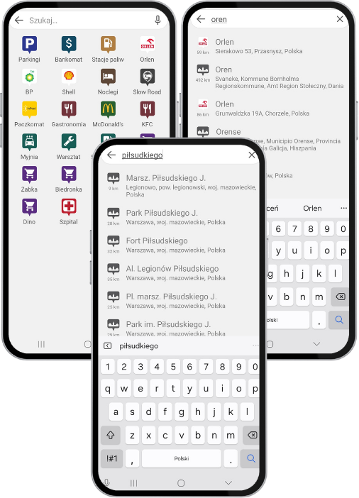
Search API processes any string provided as input, returning a single address or POI for an exact match or a list of matching results if the input corresponds to multiple locations. The partial matching mechanism implemented in the API enables the system to locate results even for incomplete names, such as fragments of city or street names, while handling typos eliminates concerns about query accuracy. Furthermore, each result includes precise geographic coordinates, enabling immediate geocoding. The combination of intelligent search and geocoding ensures that our API quickly and accurately identifies addresses and POIs, significantly enhancing the user experience.
CONTEXTUAL SEARCH BASED ON LOCATION:
The API returns various types of results (POIs, addresses, streets, etc.) and provides information about the distance from a reference point. Thanks to this, users can quickly find what they’re looking for, considering their nearest surroundings.
SEARCH API DOCUMENTATION:
SEARCH API
WHY IS IT WORTH IT?
SEARCH WITH GEOCODING:
The Search API accepts any string of characters, allows for partial matches, handles typos, and intelligently suggests the best matches. Each result includes precise geographic coordinates, enabling immediate geocoding. By combining smart search and geocoding, the API allows for fast and accurate finding of places, addresses, streets, and POIs, even with incomplete data.
CONTEXTUAL SEARCH BASED ON LOCATION:
The API returns various types of results (POIs, addresses, streets, etc.) and provides information about the distance from a reference point. Thanks to this, users can quickly find what they’re looking for, considering their nearest surroundings.
SEARCH API DOCUMENTATION:
MORE ABOUT SEARCH API
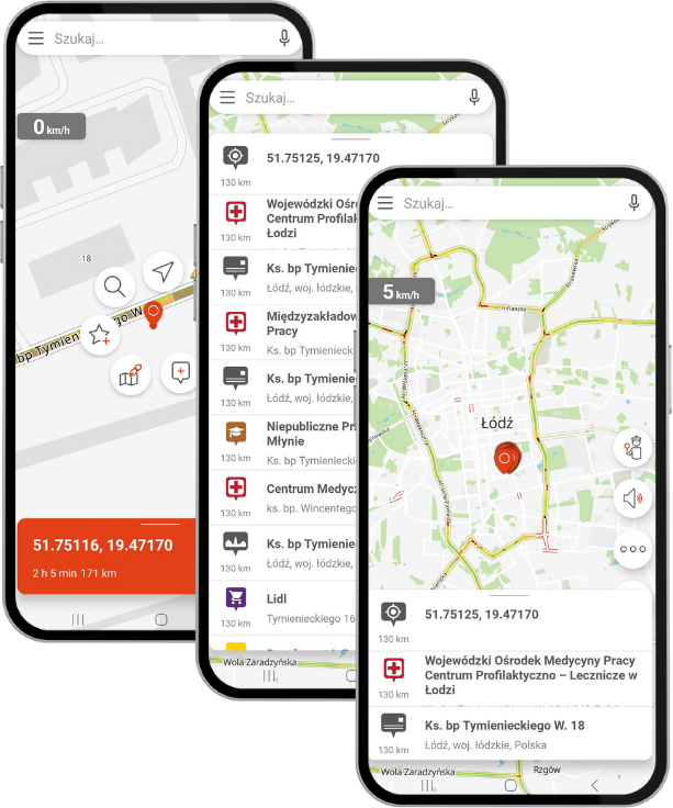
REVERSE GEOCODING:
A dedicated Reverse Geocoding endpoint returns the closest address and POI for given coordinates or lists of coordinates. This is critical for applications like location-based services or fleet management.
FLEXIBLE QUERY PARAMETERS:
Query customization is possible through parameters like result limits or excluding specific POIs via the excludePois parameter. This helps deliver more relevant and personalized results.
USE CASE
A taxi app user wants to request a ride home. The current location is automatically converted to the nearest address using the reverse geocoding method, ensuring that the passenger knows the driver will pick them up from the correct spot. The user can also type any string (with typos allowed), and the Search method will convert it into a list of potential destinations. Once selected, the app geocodes the location, immediately showing distance and estimated fare.
ROUTING API
WHY IS IT WORTH IT?
ROUTES BASED ON ALWAYS UP-TO-DATE DATA:
Our proprietary online Community Traffic technology allows us to monitor the average speeds at which cars travel on roads in real time. The diversified sources of this information are reliable because they come from drivers using our applications, such as NaviExpert navigation, Rysiek Widzimisie road warning, and professional fleet monitoring, including, among others, the NaviExpert Telematics system. The routes provided will include the latest data on traffic jams and road obstructions.
RICH SET OF DATA FOR EVERY ROUTE:
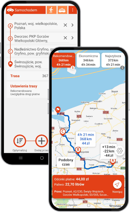
The Routing API is not just about planning the current route along with its visualization, but also a source of data for analysis. The route includes both the current and standard travel times, as well as information on obstacles and hazards.
Additionally, the user can choose from various types of routes (e.g., Recommended, Fastest, Major, Short, 4×4, ECO), enabling the travel plan to be precisely tailored to individual needs.
ROUTING API DOCUMENTATION
ROUTING API
WHY IS IT WORTH IT?
ROUTES BASED ON ALWAYS UP-TO-DATE DATA:
Thanks to our proprietary online Community Traffic technology, we monitor average vehicle speeds on roads in real-time. These diversified and reliable data sources come from drivers using our apps like NaviExpert.
RICH SET OF DATA FOR EVERY ROUTE:
The Routing API is not only about generating the current route along with its visualization, but also a valuable source of data for analysis. Routes can be tailored to user preferences and divided into various types (including Recommended, Fastest, Main Roads, Shortest, 4×4, ECO). The routes take into account roadworks, are updated with the latest road sections, and avoid congested areas. They enable precise travel planning and improve operational efficiency.
ROUTING API DOCUMENTATION:
MORE ABOUT ROUTING API
COMPUTE TRIPS:
Calculates a single route or a recommended route along with two alternative routes.
It provides route geometry, information about slow-down locations, route length, current travel time, standard travel time, route description, fuel consumption, and the number of alerts such as accidents, police checks, etc.
TRIP DECSIPTION:
Calculates a single route and provides a summary, including its length, travel time, and route overview.
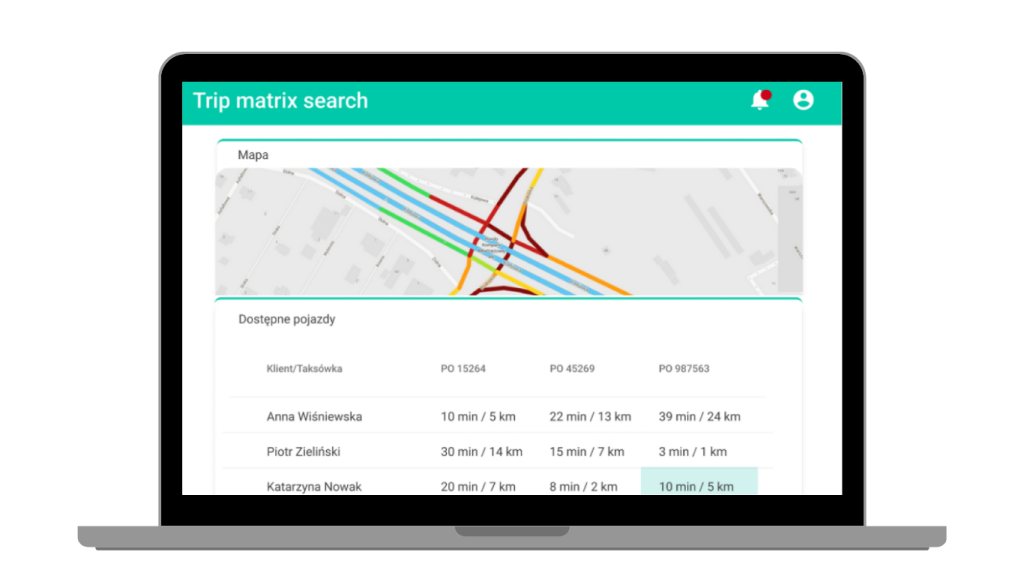
TRIPS MATRIX:
Calculates a route matrix between specified locations (e.g., multiple passengers and multiple drivers), allowing you to find the best matches, such as the closest driver for a passenger.
OPTIMIZE POINTS:
Optimizes multi-point route sequencing by solving the Traveling Salesman Problem (TSP).
USE CASE
A taxi company needs to optimize the matching of drivers to rides. The Routing API: Trip Matrix Search method enables the creation of a trip matrix for multiple destination points (taxi passengers) and multiple starting points (current taxi locations). By comparing travel time and distance data, it becomes possible to select the driver who can reach a given passenger the fastest. This ensures that each taxi optimizes its passenger service times, minimizes the time spent traveling to the next passengers, and increases overall efficiency.
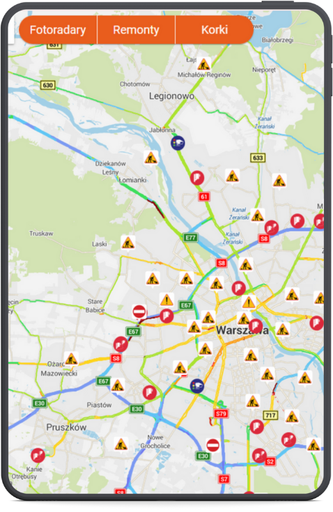
WARNINGS API
WHY IS IT WORTH IT?
ROAD INFORMATION WHAT YOU NEED
ROAD INFORMATION WHAT YOU NEED
CB WARNINGS - POLICE CHECKS, SPEED CAMERAS:
Thanks to Community CB technology, which utilizes multiple sources of information, our system receives thousands of alerts about current road events.
WHAT ARE OUR DATA SOURCES?
DRIVER REPORTS:
Drivers traveling with our apps report over 400,000 road warnings each month and our staff in moderation centers verify the information flowing into the system to ensure it is as reliable and up-to-date as possible.
INTERNET AND RADIO STATIONS:
We monitor the Internet and radio stations, selecting and adding to the system events that may affect driving comfort.
ROAD REPAIRS AND MAP CORRECTIONS:
Our team updates maps daily with information about repairs, changes in traffic organization, temporary closures of roads, as well as new road sections opened to drivers.
WARNINGS API
WHY IS IT WORTH IT?
ESSENTIAL ROAD INFORMATION
CB WARNINGS - POLICE CHECKS, SPEED CAMERAS:
Thanks to Community CB technology, which utilizes multiple sources of information, thousands of warnings about current road events are fed into our system.
DATA SOURCES:
DRIVER REPORTS:
Drivers traveling with our apps report over 400,000 road warnings each month and our staff in moderation centers verify the information flowing into the system to ensure it is as reliable and up-to-date as possible.
INTERNET AND RADIO STATIONS:
We monitor the Internet and radio stations, selecting and adding to the system events that may affect driving comfort.
ROAD REPAIRS AND MAP CORRECTIONS:
Our team updates maps daily with information about repairs, changes in traffic organization, temporary closures of selected roads, as well as new road sections opened to drivers.
TRAFFIC API
WHY IS IT WORTH IT?
LARGEST ROAD NETWORK COVERAGE:
Our Traffic API covers the largest road network in Poland, providing accurate data for both major highways and local roads.
MODELING MANEUVERS AND PATHS:
We offer detailed data on specific maneuvers, such as left turns, which enhances navigation precision.
ADVANCED TRAFFIC PREDICTIONS:
We provide journey time forecasts based on the analysis of historical and real-time data, enabling advance planning and avoidance of future disruptions.
REAL-TIME INFORMATION ON ROAD OBSTRUCTIONS:
We provide real-time data on road repairs, closures, accidents, marathons, and other obstructions, enabling dynamic responses to changing conditions.
USE CASE
A company providing VRP (Vehicle Routing Problem) services for courier companies needs to calculate a set of optimal routes for its clients. By utilizing the Traffic Snapshot method, it can retrieve current speeds for the road network in Poland and calculate a reliable estimated time of arrival (ETA) for each route. Additionally, using the Road Situations service, it maintains access to information about road closures and maintenance, allowing it to adjust certain routes. This approach enables more realistic planning of couriers’ schedules and reduces the number of undelivered shipments.
TRAFFIC API
WHY IS IT WORTH IT?
LARGEST ROAD NETWORK COVERAGE:
Our Traffic API covers the largest road network in Poland, providing accurate data for both major highways and local roads.
MODELING MANEUVERS AND PATHS:
We offer detailed data on specific maneuvers, such as left turns, which enhances navigation precision.
ADVANCED TRAFFIC PREDICTIONS:
We provide journey time forecasts based on the analysis of historical and real-time data, enabling advance planning and avoidance of future disruptions.
LIVE ROAD DISRUPTION INFORMATION:
We provide real-time data on road repairs, closures, accidents, marathons, and other disruptions, enabling dynamic responses to changing conditions.
USE CASE
A company providing VRP (Vehicle Routing Problem) services for courier companies needs to calculate a set of optimal routes for its clients. By utilizing the Traffic Snapshot method, it can retrieve current speeds for the road network in Poland and calculate a reliable estimated time of arrival (ETA) for each route. Additionally, using the Road Situations service, it maintains access to information about road closures and repairs, allowing it to adjust certain routes. This approach enables the company to make courier schedules more realistic and reduce the number of undelivered packages.
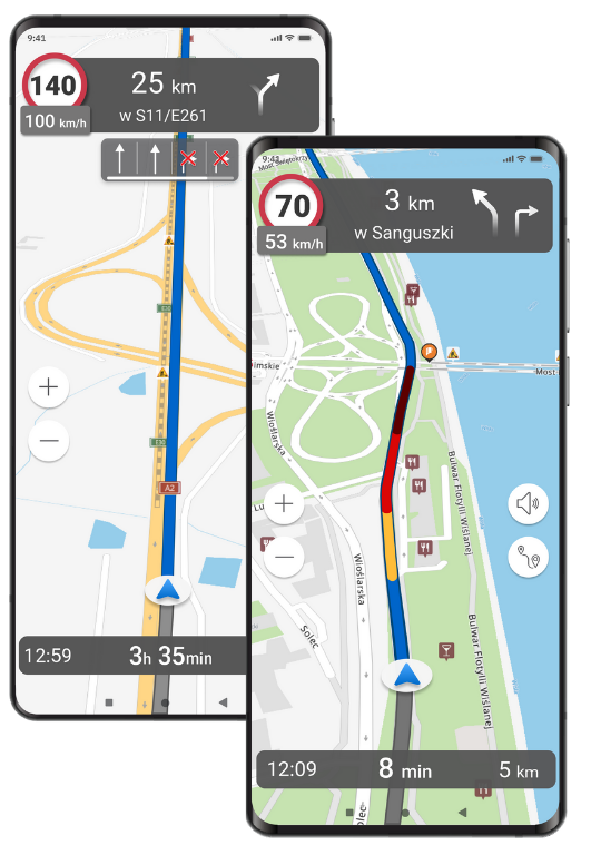
ANDROID NAVIGATION SDK
USE CASE
A courier company wants to streamline the daily work of its drivers by providing them with a comprehensive tool in a single mobile application. It has its own IT department and an order management application, but every courier has to manually copy addresses to an external navigation app. Thanks to the integration with Navigation SDK, it is possible to quickly add precise online navigation directly to the corporate application—without needing to switch between systems. This convenient solution increases the efficiency of the couriers’ work and reduces the number of errors in deliveries.
WHY IS IT WORTH IT?
Add proven navigation features known to NaviExpert users to your mobile application. The Navigation SDK is a solution designed with flexibility and reliability in mind, based on precise online map and traffic data as well as advanced route calculation algorithms – ensuring high accuracy in reflecting the current road situation for end users.
CUSTOMIZE THE INTEGRATION:
- quick integration with a ready-to-use navigation view in the application — using a single method,
- flexible use of individual interface components,
- the ability to power your own UI with navigation data (travel time, maneuver instructions, and more).
Create applications that guide users reliably and effectively — regardless of the industry.
WOULD YOU LIKE TO TEST OUR SOLUTION OR GAIN ACCESS TO DOCUMENTATION AND DEMO APPLICATIONS?
ANDROID NAVIGATION SDK
USE CASE
A courier company wants to streamline the daily work of its drivers by providing them with a comprehensive tool in a single mobile application. It has its own IT department and an application for managing orders, but each courier has to manually copy addresses into an external navigation app. Thanks to the integration with Navigation SDK, it is possible to quickly add precise online navigation directly to the company’s application — without the need to switch between systems. This convenient solution increases the efficiency of the couriers’ work and reduces the number of errors during delivery.
WHY IS IT WORTH IT?
Add proven navigation features known to NaviExpert users to your mobile application. The Navigation SDK is a solution designed with flexibility and reliability in mind, based on precise online map and traffic data as well as advanced route calculation algorithms – ensuring high accuracy in reflecting the current road situation for end users.
CUSTOMIZE THE INTEGRATION:
- quick integration with a ready-to-use navigation view in the application — using a single method,
- flexible use of individual interface components,
- the ability to power your own UI with navigation data (travel time, maneuver instructions, and more).
Create applications that guide users reliably and effectively — regardless of the industry.
WOULD YOU LIKE TO TEST OUR SOLUTION OR GAIN ACCESS TO DOCUMENTATION AND DEMO APPLICATIONS?
Pricing
Search API
Documentation
Documentation
Documentation
Documentation
Routing API
Documentation
Documentation
Documentation
Documentation
Documentation
Warnings API
Traffic API
Documentation
Documentation
Navigation SDK
PRICING
Search API
Routing API
Warnings API
Traffic API
Navigation SDK
COOPERATIOn
SUPPORT
Direct support from developers for developers in Polish. We are a Polish company based in Poznan. We respond quickly and react to our customers' requests.
QUALITY AND KNOW-HOW
The best data quality updated in real time. There is no better provider of location and navigation services that takes into account the specifics of the Polish road environment.
DATA UPDATED ONLINE
The data powering our API services is of very high quality, sourced from drivers using our applications: NaviExpert Navigation, the Rysiek Widzimisie road warning app, and professional fleet monitoring, including the NaviExpert Telematics system.
COOPERATION
SUPPORT
Direct support from developers for developers in Polish. We are a Polish company based in Poznań. We respond quickly and react to our clients' requests.
QUALITY AND KNOW-HOW
The best quality data updated in real-time. There is no better provider of localization and navigation services that considers the specifics of Polish road conditions.
DATA UPDATED ONLINE
The data on which our API services are based is of very good quality, sourced from drivers using our applications: NaviExpert navigation, Rysiek Widzimisie road warning system, and professional fleet monitoring, including the NaviExpert Telematics system.
FILL OUT THE FORM TO SPEAK WITH OUR ADVISOR
GDPR INFORMATION OBLIGATION
In accordance with Article 13 of the GDPR*, we inform you that:
1. The controller of your personal data is Telematics Technologies sp. z o.o., headquartered at Al. Jerozolimskie 181B, 02-222 Warsaw, Poland.
2. Your data will be processed for the purpose of communication regarding services provided by the controller – legal basis: Article 6(1)(a) GDPR (consent) and Article 6(1)(f) GDPR (legitimate interest of the controller in marketing its own products).
3. Your data will be stored until consent is withdrawn or an objection is raised.
4. You have the right to request access to your data, rectification, erasure, or restriction of processing, to object to processing, and to data portability. You also have the right to withdraw consent at any time without affecting the lawfulness of processing based on consent before its withdrawal. You can exercise your rights at telematicstechnologies.com/rodo.
5. You have the right to lodge a complaint with the President of the Personal Data Protection Office (ul. Stawki 2, 00-193 Warsaw, Poland).
6. Your data may be transferred by the controller to recipients providing server services, IT system support services, and database management services, including entities outside the EEA (USA). Data transfers outside the EEA are based on standard contractual clauses available for review at the controller’s headquarters.
7. Providing personal data is voluntary; however, failure to provide it may result in the inability to process your inquiry and continue communication. Your data will not be used for automated decision-making or profiling.
8. Contact with the Data Protection Officer: iod@telematicstechnologies.com.
*GDPR – Regulation (EU) 2016/679 of the European Parliament and of the Council of April 27, 2016, on the protection of natural persons with regard to the processing of personal data and on the free movement of such data, repealing Directive 95/46/EC (General Data Protection Regulation), OJ L No. 119, May 4, 2016.